So no meandering jet streams or mid-latitude cyclones or anything, but I've had enough trouble even figuring out where to start on a more legitimate climate and weather simulation that I decided to just bring the old broken one into the tectonics simulation as a placeholder.
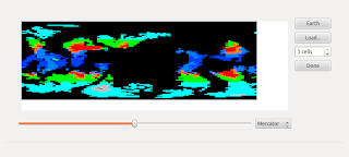
Here's my fake climate simulation at work:
Note the great Saudi Arabian jungle, the desert in the Southeast US (but not the Southwest), the frozen British Isles, &c.
So despite the brokenness, I wanted to get some sort of climate system in so it could contribute to the erosion algorithm, modulating the erosion amount from each tile by its annual precipitation and "polar" status (on the theory that glaciers cause a lot of erosion regardless of precipitation).
Compare erosion under the old algorithm (reddishness represents height lost to erosion, greenishness height gained by deposited eroded sediment):
versus the new erosion modulated by precipitation:
I had to tweak a magic number that had been picked to keep mountain building and erosion somewhat in balance. But after that, a newly created world came out looking pretty good:
and its "climate":
In any case, it doesn't really change the current simulation very much, but it does lay the groundwork for some more interesting recording of geological history. Source.


No comments:
Post a Comment